Karen & Collins Great RV Adventure

Karen & Collins Great RV Adventure

It is not the Destination, but the Journey

Wednesday, October 3, 2012

OREGON COAST

Don't forget, you can double click the pics to make them larger!

Sept 5th we pointed the RV toward the Oregon coast.  We were moving to Sunset Bay State Park, which is between Bandon to the South & Coos Bay to the North.


Coos Bay
So far, we’ve been impressed with Oregon’s State Parks.  They have full hookups (water, sewer & electric) and they can accommodate an RV the size of ours.  One couple of our RV friends, Dee & Jim, would hate it.  It’s actually like camping!!. There are a lot of trees & bushes here & most of the sites are somewhat private.  A lot of people actually “camp in tents”.  This kind of surprises me because the weather isn’t all that great.  It’s been in the 60’s during the day & the 40’s at night.  In addition to that, we’ve had no sun, except yesterday & you get a very heavy mist at night.  I think it even rained some last night.  We lucked out & actually got our satellite to work! We decided to check it out before we set up & found if we moved the RV back, just a little, it would connect!  However, we’ve had no phone or wifi service here, so once again, we take the computers when we go out!

Yurts are very popular here.  There are quite a few in this campground.

They’re basically a round tent on a platform.  They have skylite domes, & flapped & screened windows.  They come with some kind of beds & electric & a few other basics.  I don’t know if these have water, many don’t.  I’d take them over a tent any day!
We’ve done a little sightseeing while here.  The towns around here are mostly fishing towns so there isn’t a lot to see.  The other day we drove to one of the parks down the street that is really an arboretum. 

We’ve missed a lot of the flowers, especially the rhododendrons, but the Dahlias were in full bloom & spectacular.  Some are the size of dinner plates & the colors are outstanding!

They also had a lot of roses & most of them were still blooming.  They were so pretty, but unfortunately, most had little or no fragrance.


We also took a walk down to the beach where you could see, and hear, thousands of seals & sea lions.  Unfortunately, they were in the water or on the rocks of the outer islands, so we couldn’t see them up close.
Friday the 7th was my birthday, & unknown to me, Paula, our daughter, had asked Collins to pick up some flowers for me.  Poor girl, she tried so hard to have them delivered to me, but that was an impossible task.  Anyway, Collins was her courier & they were beautiful & appreciated!
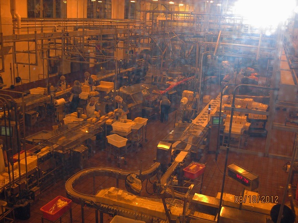

We went out for dinner that evening, which we don’t do often.  Most of the time, it’s lunch out while we’re sightseeing.  For my wine connoisseur friends & family you’ll cringe when I tell you this.  The restaurant had a little thing on the table mentioning on Oregon made Cranberry Wine.  They had several different blends & the waitress said I was welcome to taste whichever I wanted.  I tried the Cranberry Raspberry, which I found delicious!    It’s actually an award winning wine.  The next day, we went to the Cranberry Festival in a small town named Bandon & bought several bottles.  Bandon is another small fishing town & we enjoyed wandering thru their downtown.  We watched a couple of guys carving with chain saws.  That is really an amazing art!! 
                                               
Chain Saw Carving


Finished Products


They had plenty of cranberry food items & I settled on a cranberry oatmeal cookie, which was delicious.   It was a fun way to spend a day. 


There is a small stretch of beach across the street, so yesterday the dog & I went for a walk.  There are some tide pools there.  It was low tide so I was hoping to see some tide pool creatures.  Altho the area was interesting, no creatures were to be seen.  Since the sun had decided to appear for the first time since we’ve been here, we enjoyed our walk.


There are lots of wild blackberry bushes here.  We’ve probably picked a couple of gallons of them.  I had taken the dog for a walk one day & when I got back, Collins was coming back from picking a huge bowl full.  It was overflowing, but I took some out for our morning cereal before I took the picture.


Tues,Sept 11 we moved on a little further up the coast to Beverly Beach State Park, which is just outside Newport.  The drive here was so beautiful.  The Oregon coastline is probably the most beautiful we’ve seen.  There are lots of rocky cliffs & wide stretches of sand.  When you’re driving the RV you really can’t do too much sightseeing so we decided we would drive back & really check it out.  I thought the dunes extended closer to Newport, so we didn’t stop along the way.  I realized after it was too late, they didn’t come this far & we really didn’t want to drive back to take a look.  If we’d know better, we would have stopped along the way. 


The park is very nice, but you definitely feel like you’re “camping“ here, too.  There are about 250 RV, tent & Yurt sites here.  There are a lot of trees &  no TV again.


We’re here for 10 days, so we’ll get lots of reading done.  Collins & I like to play a dice game called “Farkle”, so I’m sure we’ll have time for some of that.  We do get internet & phone, but it’s not the greatest!  The weather here is pretty consistent – mid to upper 50’s in the day (even some sun a few of the days) & low 50’s at night.  It doesn’t feel too bad because it hasn’t been windy.
One of the sunny days, we took our bikes over to the beach.  The dog likes to run in the sand.  She runs ahead for a little ways, then stops to make sure we’re foll  owing.  There was a creek from the campground that ran to the ocean.  We hopped across it when we were close to ocean, but when we came back we had walked higher up on the sand & the creek was much wider.  We found a log to go across.  Collins went first, no problem.  Me, forgetting how uncoordinated I am, picked up the dog & started across.  Of course, I lost my balance, dropped the dog & landed in the water, which wouldn’t have been bad, except that my foot got caught in the rocks, I twisted my ankle & landed totally in the water.  It would have been pretty funny, except that I hit one leg on the rocks, which brought about huge swollen bumps because my veins are very close to the surface & of course my foot was stuck & twisted.  Luckily, all I did was sprain my ankle, which looked like it belonged to an elephant for several days & had plenty of bruises on the other leg.  I really should have known better. 
Mostly, we’ve just been enjoying the coast & the small towns around here.  The day we drove back to see some of the coastline, we stopped in a couple of the towns.  One had a farmers/flea market going on, we bought some produce but also had to sample some of the local baked goods.  We also went to some little shops along the Newport Bay.  There were tons of Sea Lions there.  Some of them looked like they were posing for us.  There is a big rock in the bay where they like to stay during the day.  You can hardly tell the sea lions from the rocks.


We took a trip to Tillamook to check out the cheese factory.  The drive there was very scenic, we even saw some “elk crossing” signs, but no elk.  I was a little disappointed in the Cheese Factory itself.  We did get to see some of the packing going on, but that was about it.  Tillamook is very well known for its Cheddar Cheese, but they make all kinds, plus ice cream & butter. 


We also checked out Yaquina Headland.  There is a lighthouse there, which we didn’t go into, but we did see some gray whales, which tend to be in this area year round.  We also walked down to the tidepools, but didn’t really see any critters.  We did see some harbor seals on the rocks, there were several large ones on one rock & their pups were on another.


Harbor Seals & their pups - you really need to enlarge this to see them


Whale to the right of the big rock
There were gray whales to the right of the big rock.

This has been a nice park for bike riding & walking, which we’ve done a lot.  At least it’s good exercise for all of us. 
Sept 21 we left the coast & were off to Eugene.  Time for a little routine maintenance on the motorhome.  On the advice of some friends, we spent the weekend at the Armitage County Park Campground.  It was really nice with full hookups, paved pads & grass.  It was also our 27th Wedding Anniversary.  Hard to believe it’s been that many years already!

We decided to go to the their Saturday Market, which is massive & sells most everything one can grow or make at home .


While we have seen occasional pockets of a few hippies throughout California & the lower Oregon coast, today we hit the mother load.  I've included  two pictures of a small fraction of their representation; suffice it to say, it brought back nostalgic days of old.  For the uninformed, those glass things in front of the sitting guy are bongs;  the woman on the right in the second picture is no college student, or hasn't been one for at least 40 years, & is "free dancing" with the music. I suspect she already owns her bong.


Traveling has brought about frequent learning days, some historical, some scenic, some, like today, just informative.  The University of Oregon is in Eugene & today they are having a football game with someone or other.  The learning point is, they are called the "Ducks".  So there I am, (Collins)  trying to figure out what group of idiots sat around one day & said:  our team needs a mascot....  lets call them the Ducks, & then everyone else agreed.  That level of thinking goes beyond the water they drank; I'm sure it had to do with prior hippie influence.  Not wanting to take anything as important as this for granted, I asked some of the numerous fans camped around our site about its origin & was told it actually had nothing to do with their smoking choices but rather started with the team being called the "Web Feet" (swear to god).  Then some group of intellectuals decided that name wasn't appealing so, lo & behold they came up with Ducks.  I guess if you think about it long enough, it may be an improvement but hey, it's their school. Now don't you wish you were traveling around learning all this neat stuff?

 Saturday evening we were sitting out having a drink as people were leaving for the game. I (Karen) wanted to say “ Quack, Quack”  as they drove by, but Collins thought that would be inappropriate!  I figured since their team was named the Ducks, that would be the right call,sort of like “good luck” but in the end, I just waved & smiled.

Sept 23rd we moved to what I called “Camp Cummins”.  It was the parking lot of the Cummins repair facility in Eugene.  We decided to go there for some routine maintenance.  They have water & electric hookups for those having RV repair work done.  Since we had to be there at 8AM, which is early for us, we decided to get there Sunday night.  There was one other RV who had spent the weekend there.  Not too long after they took our coach into the repair shop we received a phone call telling us our diesel turbo charger was bad & needed replacing.  There were also a couple of recall issues that would need parts, not available til the next day.  Luckily for us, our Good Sam warranty company covered the Turbo Charger & Monaco covered the recall Items, so we were pretty fortunate when all was said & done.  By Monday night, there were 6 Rv’s at “Camp Cummins” & we met some nice people & picked up some useful information.  RVers are really good at sharing tips with each other.  We also saw a nice "Hippie Bus" come in, and out climbed 3 people with wild tie dye shirts.   I couldn't get my camera fast enough to get their pics!

We ended up spending 3 nites there, but we had water & electric hookups for the RV at night  & their waiting area was comfy.  We did some running during the day & took our bikes to the park.  We were very thankful they found the problems before we had a breakdown on the road.
Sept 26th they finished our repairs & we were off to Prineville Reservoir State Park sort of in the middle of Oregon.  There is a huge reservoir here with a very nice State Park.


Moon on Prineville Reservoir


We were very surprised the first evening we were out walking the dog to see about a dozen deer roaming one of the grassy areas of the park.  I guess they come there every night & they certainly aren’t afraid of people or little dogs.  We had gone for a walk while it was light, but stopped to talk to some people & it got dark.  As we headed back the way we had come, Snuggles went on the grass to potty.  All of a sudden, I looked over to see a deer headed toward her.  I yanked her out of there in a hurry.  They also decided they liked this beautiful plant I’ve been carting around for the past 2 years.  It was getting rather large & I had just said to myself the other day, I needed to trim it some.  Well, the first night we were here, the deer decided to trim it for me – a little more than I had planned.  It still looks ok, but sure isn’t as full on one side as I would have liked.  Now we put it inside at night!

We mainly came here because I wanted to see a place called The Painted Hills.  It’s about an hour from where we’re staying, so we took a drive there yesterday.  As we drove down the cutoff road, we rounded a curve & there was the first colorful hill.  Collins & I both said “Oh my gosh!” at the same time. 


These hills look like someone came in with a paintbrush.  They were formed by Volcanic Ash & erosion & I have to say, they were amazing.  We both agreed that was well worth the trip.  These pictures do them not justice.


We also made a side trip to a place called Smith Rock State Park.  I had read somewhere it was popular with climbers.  It wasn’t real far, so we decided to take a ride. 

Smith Rock & The Crooked River


The rocks are pretty as you drive into the park.  We got there late in the day & saw quite a few groups who had finished climbing.  When we looked carefully, we could see quite a few still climbing & a few at the top itself.  Not something I would want to do, but I give them credit.  It wasn’t as impressive as the painted hills, but we did enjoy the visit.


This is the one most of them were climbing


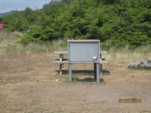
As usual, I have my odd pics of weird trees & strange signs. 

This sign we saw along the coast of OR.  I finally asked one of the park rangers what that was all about.  He said those were the areas that weren't high enough for you to remain if a Tsunami was coming.  Of course, you can imagine the chaos you'd have if there were an actual warning.  And, most of the time, there isn't enough time to go far.

Here are my weird trees for this trip.
They called this an octopus tree


Tomorrow we're moving to a place along the border of Oregon & Washington.  It's the Columbia River Gorge.  More updates later!!

Tuesday, September 4, 2012

VOLCANO COUNTRY


July 12th we left the Yosemite area for an area outside San Francisco called Fairfield.  We were staying at Travis Air Force Base.  We were so happy to see grass again.  Ever since we left Texas, our sites have been gravel, sand or dirt.  It’s so hard to keep things clean!  Our poor dog has gotten a lot of baths this year!  We stayed at Travis 2 weeks, met some very nice  people & got a chance to do some sightseeing.   There were a lot of “jack rabbits” there.  They had really long legs & ears.  I tried to get a pic when they were running but they were too quick for me.


Karen in China Town

We were about an hour outside San Francisco so we decided to take the train for our day in the city.  We certainly got a workout that day.  Our first stop was China town, which was an uphill walk from our train stop.  We wandered around there for a couple hours, had some egg rolls & did some window shopping. 


Collins riding the cable car

When we were ready to go down by the bay, we decided to catch a Trolley.  That was easier said than done.  About 6 full ones passed us by, before we were able to hop aboard.  It was packed.  I was squished inside & Collins was hanging on outside. 


Crooked Street


We went up & down hills, passed the most crocked street & finally reached the very end (or beginning) of the Trolley route at the San Francisco Bay. 


High on a Hill in San Francisco


We walked along the park by the bay for awhile & down to Ghirardelli Square.  There was chocolate in many flavors & an ice cream parlor with more chocolate items then you can imagine.  After we got our share of Chocolate goodies, we continued our walk toward the piers. 


Street Car

Trolly
San Francisco Bay with Alcatraz in background
San Francisco Bay with Golden Gate Bridge in Background
Collins enjoys some oysters

 By this time we were ready for some real food so we stopped into one of the seafood restaurants along the pier for a fish dinner.  After a filling & delicious dinner, we finished our walk along Pier 39. 


Telegraph Hill


At that point, we decided it was time to head for home & wandered back to the train station.  We were totally worn by the time we returned to our comfy little home.


Napa Winery


Another day, we decided to drive to Napa Valley to check out some of the nice little towns & wineries.  Now some of you know, neither one of us are much into wine, so it was more looking around than anything else for us. 


Winery

We did taste some sweeter wines at one of our stops, but nothing really grabbed us.  Collins says we need something they crushed the day before!  Some of these wineries are large, with pretty gardens & beautiful settings. 


 We also drove to the Culinary Institute, which is housed in an old monastery.  We didn’t eat there since we arrived between meals, but we went inside & looked around a little.  It is a huge facility & has students from around the world.


We bought a new bike rack while in Fairfield.  The day we left Yosemite, one of the bikes fell off the rack we had purchased when we bought the bikes.  Thankfully, it happened just as we pulled out of the park & several nice people honked to let us know.  We had the bikes on the back of the car & we can’t see the back so we had no idea.  We have a rear camera in the RV but you can’t see what’s going on at the back of the car.  After we got the bikes secured again, we made a decision to buy a rack that goes into a trailer hitch on the car & the bikes set into the rack.  However, we didn’t have a trailer hitch so we had to get that installed.  We found a place close to the base to get that taken care of.  We both felt a lot better the next time we traveled with the bikes. 
Port Reyes Post Office


Another day we decided to make a trip to Reyes National Park.  It is a peninsula located along the west coast just north of San Francisco.  We started our exploration at Point Reyes Station, which is a very small town as you cross onto the peninsula. 


Port Reyes Hardware Store

There was a post office & hardware store, along with a few small restaurants & misc shops. 


Creepy Tree we saw on the mountain
Drakes Bay & The Pacific Ocean


Our travels around Point Reyes Park took us thru several types of terrain.  We took a trip up a very narrow road to the top of Mt. Vision.  The views were really spectacular.  As Collins & I have said so many times, you can take all the pictures you want, but they never do the actual scenery justice.  The day was clear & you could see Tomales Bay, Drakes Bay & the Pacific Ocean from the top.  We enjoyed a picnic lunch while sitting on a log. 
Tomales Bay


Pacific Ocean at Point Reyes
Colorful Ground Cover along the beach

The coastline was very rugged & where there was a beach, they suggested you not go in the water because the currents were so strong!   We did notice as we drove down to the beach, they had a lot of groundcover growing in the sand.  It was very colorful.  The weather changes were crazy!  It was in the 60’s the whole day there, but when we returned to our RV it was in the mid 90’s at 6pm.


Old Lifeguard Station in Drakes Bay
California Hills
Collins & Snuggles on the bridge

We also decided to cross the Golden Gate Bridge.  We were going to ride our bikes across, but heard the path to & from the bridge was very steep.  Since we aren’t so good on our bikes anyway, we decided we’d better walk across.  That was the best decision we could have made.  They only had one side of the pathway opened & it was for pedestrians & bikers going both directions.  I would guess, at it’s widest point, that path was no more than 6’.  Just walking it was nerve-wracking.  It was extremely windy, crowded & very noisy.  It’s about 1.7 miles each way.  At least we can say, “We did it!”  Once is enough tho!! 


Golden Gate Bridge

View of San Francisco from the Golden Gate Bridge

July 26th we said goodbye to the San Francisco area & pointed ourselves to the north.  Since we were about an hour outside of San Francisco, we decided to take the Interstate instead of Hwy 101.  We knew it would be 2 lane in many places & usually a fair amount of traffic.  Big mistake!!  The interstate was great , but when we got to Redding, CA we were in for a “bad trip.”  We should have checked more closely, which I now do, but we had to go thru the Trinity Mts & that was not a fun trip.  We’ve driven thru a lot of Mts in the past 2 years, but no road as bad as that.  It was twisty & turning the whole way, which was about 125 miles.  You think, ok maybe 2 hrs, It was closer to 4.  It was 2 lanes most of the trip & sometimes I wasn’t sure if we were going to kiss the Mts next to us or go over the cliff.  Many places had almost no shoulder & no guardrail.  We were exhausted when we finally arrived in Trinidad. 
Patrick's Point, Trinidad

We chose Trinidad so we could see the Giant Redwoods.  Trinidad is a small, rocky coastal bay town.  The weather wasn’t great for beach time, but we did take a couple of strolls. 

There was an area called Agate beach right next door.  Apparently, if you know what you’re looking for, there are plenty of agates, which are gemstones, to be found there.   They aren’t polished like you get in a store so it’s hard to tell if you’ve just found some pretty rocks or you actually have agates.  I came away with a handful of pretty rocks & maybe one or two are actual agates!


Gravel Road to Fern Canyon

One day we drove North.  We saw redwoods & drove to a place called Fern Canyon.  I thought Collins was going to kill me by the time we arrived there.  It was about 10 miles back on a pot holed, gravel road (reminded us of Costa Rica).  


Fern Canyon

The canyon was pretty, all different kinds of ferns growing on the walls. 


Fern Canyon

We also saw a field full of Roosevelt Deer.  Most of them were lying down or too far away for good pics.  We were close to the State Park so one day we walked over just to see what we could of the beach – not much! 
Food locker in bear country

There was tent camping on that beach & I took a picture of the locker people had to use to store their food.  There are bears in most of the forested areas up there & those lockers prevent them from seeing or smelling the food.  It helps keep them out of the area. 


 It was in the 60’s our whole time there, & we didn’t see much sun.  I guess that is pretty common for that area.  We did meet some nice people in the park tho.  That park had many wild blackberries growing & they were just ripening, so we picked several bowls full.  One day I made a pie & we froze the rest for another one.  My sister, Diane, had given me a pie crust recipe you don’t have to roll; you make it right in the pie pan.  It’s so easy, I don’t mind making pies (not that I do it often).

Another day, we drove south to what is called the Avenue of the Giants.  Both sides of the road are lined with giant redwood trees, and there are special ones to see along the way. 

The redwoods are the tallest trees in the world.  They can grow to about 380’ & live about 2000 yrs.  We were amazed at their size. 


The Immortal Tree

One was called “The Immortal Tree”.  It was over 950 years old & had been thru lightning, fires & floods.  It is still growing! 

Another, called the Eternal Tree, was over 2500 years before it was reduced to a stump.  A 20’ room was built in that stump.  The stump continues to parent new off shoots. 


Inside the Eternal Tree House


Another interesting stop along the way was called Founder’s Grove.  It was dedicated to the founders of the Save the Redwoods League from 1917.  It was a very peaceful, interesting place to see. 


Collins by the roots of the Dyerville Giant


One of the most interesting, was a fallen tree called the Dyerville Giant.  It was 370’ tall, 17’ in diameter & 52’ in circumference. 


Karen next to the trunk of the Dyerville Giant


It fell when the soil became too saturated during a rainy season.  No one saw it fall, but a park neighbor about a mile away heard it & said it sounded like a train wreck.  We didn’t get to the tree you could drive thru, but there are several in the area. 


Along our route, there were several interesting little towns.  Scotia is an old lumber town.  Most of the 270 hillside homes all look alike & were built between 1920 & 1950. 


There is still a huge lumber mill on the outside of town. 


We also drove thru the Victorian Village of Ferndale.  Much of the downtown & many of the surrounding homes have preserved their historic features. 


Many of the homes had huge Hydrangea Bushes in beautiful shades of pink & blue. 


 Another day, we drove to McKinleyville to do some shopping.  They have what is said to be the world’s tallest Totem Pole carved from a single tree.   The tree itself is about 500 yrs old.


Totem Pole Top
Totem Pole Bottom
Aug 4th our week in Trinidad came to an end & it was time to move on to Hat Creek, CA, located just outside the Lassen National Volcanic Park.  Unfortunately, we had to go back across HWY 299.  I’ll just say it was another long & hair raising experience.  The only good thing I can say is some of the views were very pretty. 

As we rolled into Redding, the RV came to a complete stop at a very busy traffic light.  Several dash lights came on & we didn’t know what was going on.  We spent a very hot couple hours waiting for a tow truck & getting hooked up. While we waited, we had a Redding Fire Truck & Police car behind us.  Those people were so nice & they were the ones who got us a tow truck, when Good Sam said it would take 2 hours.  It’s pretty fascinating to watch them get an RV our size ready to tow.  Since it was late Sat. afternoon, they towed us to a campground for the weekend, hoping to find us a mobile mechanic.  Of course, that didn’t happen, so we spent the weekend in Redding.  Monday morning, Good Sam tried to find us a mobile mechanic willing to take on our unknown problem.  We finally ended up being towed to a Cummins repair shop, where we spent Monday night.  Tuesday, they figured out we had gotten air in the fuel line & something to do with the changes in air temp, caused things to lock up.  It did change our plans for a few days, but it was no big deal.  We met another couple in that park, that had come from another mountain road,  They got too close to the mountain on one of the turns & ended up tearing off the back door on one of their cargo bays of their RV & the side fender on their car & puncturing 2 car tires.  They were on a 2 lane road & couldn’t go anywhere.  They had to wait for a tow truck on the side of a mountain. 

By Tues afternoon we were back on the road to our destination in Hat Creek.  What we didn’t know, was the park we wanted to see was shut down due to a forest fire.  Besides that, we were about 25  miles from there & every morning we woke up with smoke in the air.  Most days it blew away by noon, but one day it was smoky all day & there was ash everywhere.  On top of that, we had no cell service there & our own mifi didn’t work, so we had to use their internet & we were only given 2 hours a day, which had to be used at one time.  And it was soooo slow.  We felt so disconnected.  Whenever we went sightseeing we took our computers & phone.  


We did go to Mt. Shasta, which still had snow on the top.  We took a picnic lunch & drove as far as we could up the mt. 


Mt. Shasta is a 14,162 foot volcano.  Most of the area around it is rather flat so it really stands out!  There is a lot of skiing in that area!  


View from Mt. Shasta

McCloud Waterfall

On the way home, we stopped at some pretty waterfalls.  I don’t know what it is about waterfalls, but everyone seems to like them. 


Another day we took a trip to another park that had a really beautiful waterfall, called McArthur-Burney Falls.  


Theodore Roosevelt called it the 8th wonder of the world.  It pours out an average of 100 million gallons of water per day, even in the summer & drops 129’. 


Since we were trying to do things away from our smoky campground, we also paid a visit to Medicine Lake, which was formed by the Medicine Lake Volcano.  It was very quiet there & not many people.  Getting there was very interesting.  The area around it is all volcanic rock.  Some areas looked like freshly plowed dirt, but upon a closer look, it was rock. It provided us with a great drive for the day.  You might be asking why we didn’t just leave Hat Creek, since it was smoky & we couldn’t go to the park anyway.  Well, the crabby lady who ran Rancheria RV Park, wouldn’t give any refunds, so we just decided to stay & do the rest of the planned sightseeing from there.  There were a number of people who left there quite unhappy.

Just a little unusual addition here.  I’m including a picture of Belted Cows.  We saw them for the first time in California, but they were too far away to take a picture.  When we first saw them, we wondered if someone had painted them.  I had to look them up online to see what they were.  Anyway, they had some in a pasture as we drove by, so we stopped to take a picture.
Aug. 15th we left smoky Hat Creek & aimed for an area just south of the Oregon border called Tule lake, CA.  We were planning a stop at the National Lava Beds National Park.   We’re following the Volcanic Legacy Scenic Byway.  Most of what we’ve seen since our arrival in Hat Creek has been part of that byway.  Tule lake was a tiny town just south of the Oregon border in CA.  Their fairgrounds had a great little RV park with full hookups & the greenest, thickest grass we’ve seen in a long time.  Snuggles had a great time running around there.  There were spaces for about 25 RV’s, but there were only 3 of us.  --Tule Lake was the location of the largest of 10 Segregation Camps built during World War II to house Japanese Americans (2/3 were American citizens).  They were held for over 4 years without ever being charged of any crime.  We didn’t go to see these, it was too disgusting to even think about seeing it. 


The Lava Beds Monument was formed by a shield volcano called Medicine Lake Volcano, which last erupted about 1000 years ago. 


The land wasn’t pretty like some forested areas, but had kind of a stark beauty about it.  The rock formations were fascinating.  You could see lava flow & rock shearing, etc. 


There are about 700 Lava Tube Caves, with some that could be explored. 


We went into several of them.  They aren’t at all likes the caves in AR or KY.  


Modoc Indians lived on that land for because it provided them with a natural fortress, a nearby lake, & plenty of waterfowl & game.  If any of you have studied the Indians, this is where Captain Jack was captured. 


There is a small mountain just away from the main beds, that has very interesting rock formations to it. 


The side looks sheared & there are small cave like holes where many birds call home. 


It is called Petroglyph Point because the Indians scratched many carvings (petroglyphs) into it.  It would be interesting to know what they meant.  After seeing this place, I was really sad that we hadn’t been able to get into Lassen Volcanic Park.


Aug 17th we crossed the border into Oregon.  I’ve never been in this state before.  We were booked into one of Oregon’s many State Parks, that provide full hookups (Electric, water & sewer) & can accommodate an RV our size.  They are also very reasonably priced!! 


We’re in Collier State Park, which is about 40 miles south of Crater Lake.  That was our main attraction for here.  It is truly a spectacular sight!  I will start by saying I could not take a picture to do it justice.


After the top of the volcano, Mt. Mazama, collapsed 7700 years ago, it created a caldera that filled with clear, blue water.  It is really beautiful!!  The color of the water comes as much from the sky as the waters depth.   There are two small islands in the lake; the largest is Wizard Island.  You can take a boat ride there & get out & explore if you like.


The second is called Phantom Ship.  They say in certain light it is sometimes hard to see


The lake is the deepest in the U.S.; at its deepest is 1940 ft & 7th deepest in the world.   It's so deep it has only frozen over once in the last 100 yrs. 


The rim measures roughly 6 miles across.  Draw a circle on a local map representing a 6 Mile diameter; It was one very big volcano.  The rim road is 34 miles  & half it is closed 6 months of the yr. because it's not drivable. 


Avg snowfall is 44 ft., (see  picture, & yes ,even though the temperature was 70*, that is remnants of last year’s snow we are standing in). 


By identifying some of the far off mountains & other volcanoes, we determined we could see 150 plus miles.  For Illinoisans, that would be from Elgin into Michigan, or Peoria. 


 The various formations showing what occurred over the last 7700 yrs are a Geologists dream.   This formation was callede Pummice Castle because the formation is made out of pummice.  The colors in the surrounding rocks were really pretty.  


Just trying to grasp all of what had to occur is pretty amazing.  Not surprising, the water is cleaner than what you get out of your tap.  We took a short hike into one of the meadows that had a creek running thru it.  Snuggles found the shallow water tasted very good.  We also saw a deer in the woods!


On the exterior side of the mountains surrounding the lake, there were some interesting views including this one of Videa Falls.


While the northern California Big Trees were interesting, we have been more impressed in Oregon's sites.  I'm sure this is nothing when compared to Alaska, but it's still very sobering.  Every time we stopped at a lookout, all we could say was WOW!  This particular range of Volcanoes we been following, the Cascades, goes all the way to British Columbia.
We finally got some beautiful weather.  It’s in the low 80’s during the day & mid 40’s (that surprised me) at night.  A couple of days ago, we rode our bikes to the Logging Museum, which is located close.  They had a tour which was very interesting.  They also had a lot of old logging equipment & some real log cabins they had relocated.  That had to be an extremely hard job!  Not one I’d care to try.  Today we decided to take our bikes to a really nice paved trail.  We probably rode 4-5 miles.  It was a nice way to spend a few hours.  We’ve been pretty laid back at this location.  We can’t get satellite TV because there are too many trees, & they don’t have cable TV here.  Collins was in withdrawal for the first few days, but he’s found some interesting books, so now he’s enjoying the peace & quiet.  I don’t mind at all.  Everything is either politics or reruns, so no TV is fine with me.  Since the weather has been nice, we’ve been able to take our books outside. 
The water is coming up where you see the ripples

Spring Creek, where the headwaters go

 We also took a drive to what they called the headwaters of a creek that ran nearby.  It was interesting because there were all these spots you could see the water coming up from the ground.  It’s hard to imagine those spots creating enough water for this creek.


Aug. 28th we left Colliar State Park for a place suggested by several people we met along the way.  It’s called Seven Feathers RV Resort.  It’s part of a casino, but it’s across a busy highway. 


Our spot

This place is, by far, the nicest RV park we stayed in.   The cement RV pads are well separated from our neighbors, sidewalks abound, the grounds are beautifully landscaped,with hanging pots of petunias all over & street lights that were the old 1800’s type. 


Snuggles & Collins read the paper


The grass is thick & manicured to perfection.   Snuggles loves running thru it, which is a rarity.   WIFI (very fast) & cable are free.  The public RV showers & rest rooms are all private units & absolutely spotless.  We have stayed in 5 star hotels that  weren't as nice as this.  Now we understand why everyone we encountered  that has already been here told us we had to visit the location.  Finally, in doing some on-line research, we found that this is the only RV site in the U.S.  with perfect ratings for cleanliness, & site location, & amenities from both Good  Sam & Woodalls.  In addition to an inside pool for RVers, they have shuttles 24/7 to take you to the casino, other on site facilities or the small, nearby town (don't blink).  We are going to the Casino today to check out their eateries & prices, but we have been told they are as good as everything else.   And now the kicker:  the full hook-up RV fee is $28 a night.  Also, when you get a player’s card, you get 3 cents off per gallon at their gas station, which already had really good prices.
Us at the Casino
While sitting outside in our lounge chairs last evening, enjoying our cocktail, we both joked about this being the only location we would work-camp. Oregon, with its volcano lakes & sheer beauty, has really impressed us. 

Life is good, & here it is very good.
We’ll be off to the coast for the next few weeks. 
We’re going to head back to TX pretty soon to deal with a lawsuit we’ve filed against Convenience RV, who incorrectly installed the brake cable that caused our car brakes to burn out as we started this year’s travel.